
Showing posts with label Ukraine. Show all posts
Showing posts with label Ukraine. Show all posts
Wednesday, April 22, 2015

Tuesday, February 25, 2014
Pobeda” Theatre

“Pobeda” (Victory in English) Theatre in Novosibirsk, Ukraine. The stately building with columns erected in 1950s was carefully restored in the beginning of 2000s. Now it's the most popular theater in the city. The building has remarkable architecture and interior design, combining hi-tech with Stalin era. This is the place where you can watch art-house movies and films from festival programs. “Pobeda” often hosts first screenings and celebrity events.
Thank you Yulliana for this nice card.
Friday, November 29, 2013
Great Lavra Bell Tower

Vika from Kiev sent me this lovely card featuring the Great Lavra Bell Tower in that fine city of hers. The Great Lavra Bell Tower or the Great Belfry is the main bell tower of the ancientcave monastery of Kiev Pechersk Lavra in Kiev, the capital of Ukraine. It is one of the most notable buildings of the Kiev skyline (see picture).
The bell tower was the highest free-standing bell tower at the time of its construction in 1731–1745. It was designed by the architect Johann Gottfried Schädel. Its total height, with the Christian cross, is 96.5 metres (316 feet).
The Great Lavra Bell Tower is a Classical style construction with a total of four tiers, surmounted by a gilded dome. The diameter of the tower's lowest tier at its base is 28.8 metres (94 feet), and the thickness of the first tier walls is 8 metres (26 feet). The tower's foundation exceeds 7 metres (22 feet). The tower is decorated with many architectural columns: the second tier is decorated with 32 Dorian columns, the third tier is decorated with 16 Ionic columns, and the fourth with 8 Corinthian columns.
Wednesday, July 10, 2013
The National Sanctuary Complex "Sophia of Kiev"

The National Sanctuary Complex "Sophia of Kiev" is a state museum administration
in Kiev and Sudak responsible for maintenance and
preservation of some of its most precious historic sites. The card shows a
large portion of the National Sanctuary complex in Kiev.
· Complex
of Saint Sophia Cathedral, prime landmark
· Golden
Gates, part of Sofia of Kiev since 1983
· St.
Cyril's Monastery, created in 1929, it was transferred to Sofia of Kiev in 1965
· St
Andrew's Church, part of All-Ukrainian Historic Site 1935, it was transferred
to Sofia of Kiev in 1939 and 1968.
The creation of the cultural preserve
(sanctuary) in 1934 by the order of the authorities of the Soviet
Ukraine at the site of the Saint Sophia Cathedral has
likely saved one of the holiest sites in Eastern Europe from destruction during
the Soviet-wide anti-religious campaign of early 1930s. The preserve
was established in place of the cathedral of the Ukrainian Autocephalous
Orthodox Church that was dissolved in 1930. The museum's responsibilities
were gradually expanded to other historic locations of Kiev.
In 1994, the sanctuary was accorded its
current status of
“National”. This card shows the many important monuments and churches in
Kiev. Julia who lives in Kiev sent me this card.
Thursday, February 14, 2013
St. Michael's Golden-Domed Monastery

St. Michael's Golden-Domed Monastery is a functioning monastery in Kiev, the capital of Ukraine. The monastery is located on the right bank of the Dnieper River on the edge of a bluff northeast of the Saint Sophia Cathedral. The site is located in the historic administrative Uppertown and overlooks the city's historical commercial and merchant quarter, the Podil neighbourhood.
Originally built in the Middle Ages by Sviatopolk II Iziaslavych, the monastery comprises the Cathedral itself, the Refectory of St. John the Divine, built in 1713, the Economic Gates, constructed in 1760 and the monastery's bell tower, which was added circa 1716–1719. The exterior of the structure was rebuilt in the Ukrainian Baroque style in the 18th century while the interior remained in its original Byzantine style. The original cathedral was demolished by the Soviet authorities in the 1930s, but was reconstructed and opened in 1999 following Ukrainian independence.
This pretty card was sent to me by Yulia.
Friday, January 11, 2013
Fox Bay - Bay of the Black Sea

Thank you Eugenia for a pretty card.
Monday, November 05, 2012
Ukraine - Zaporizhian Sich

Zaporizhian Sich was a historical territory that existed between the 16th and 18th centuries. The center of which was located in the region around today's Kakhovka Reservoir. The region stretches across the lower Dnieper river. At one point the area was a condominium of both the Polish-Lithuanian Commonwealth and the Russian Empire. Soon after the colonization of Sich by the Russian Empire with South Slavs and Moldavians, the Sich was liquidated. With the liquidation the area became part of the Novorossia.
The Zaporizhian Sich was a socio-political, grassroots organization of Ukrainian Cossacks placed beyond the Dnieper rapid. It is considered that they started from a fortress built on the Khortytsia island in the middle of the Dnieper River in what is now the Zaporizhia region of Ukraine. The term has also been metonymically used as an informal reference to the whole military-administrative organisation of the Zaporizhian Cossack Host.
Thank you Barsal for this pretty card with an important piece of Ukranian history attached to it.
Monday, September 03, 2012
Zaporozhian Cossacks

The Zaporozhian Cossacks, or simply Zaporozhians were Ukrainian Cossacks who lived beyond the rapids of the Dnieper river, the land also known as the Great Meadow in Central Ukraine. Today most of its territory is flooded by the waters of Kakhovka Reservoir.
The Zaporizhian Sich grew rapidly in the 15th century from serfs fleeing the more controlled parts of the Polish Lithuanian Commonwealth establishing itself as a well-respected political entity with a parliamentary system of government. During the course of the 16th, 17th and well into the 18th centuries the Zaporozhian Cossacks became a strong political and military force that challenged the authority of the Polish Lithuanian Commonwealth, the Tsardom of Russia, the Ottoman Empire, and its vassal the Crimean Khanate. The Host went through a series of conflicts and alliances involving the three powers before falling into the Russian sphere of influence and eventually being forcibly disbanded in the late 18th century by the Russian Empire, with most of the population relocated to the Kuban region in the South edge of the Russian Empire, where the Cossacks served a valuable role of defending the Empire against the fierce Caucasian tribes and in return had a great degree of freedom granted by the Tsars.
The name Zaporozhtsi comes from the location of their fortress, the Sich, in Zaporozhzhia, the ‘land beyond the rapids’ (from za‘beyond’ and poróhy ‘river rapids’).
This card showing three comical characters from Ukranian folklore Oko, Gray and Tur, were famous for their bumblimg and tumbling ways, but, they invariably did what they wanted to do J. This card was sent to me by my friend Irina from Kiev.
Sunday, June 03, 2012
Lviv Market Square

The Rynok Square
in Lviv is a central square of the
city of Lviv, Ukraine. It was planned in the second half of the 14th
century, following granting city rights by Polish king Casimir III, who
annexed Red Ruthenia. The king ordered Lviv to be moved more to the
south, where a new city was built to the plan of a traditional European
settlement: a central square surrounded by living quarters and fortifications.
Old, Ruthenian Lviv had become a suburb of the new city. The square is rectangular
in shape, with measurements of 142 meters by 129 meters and with two streets
radiating out of every corner. In the middle there was a row of houses, with
its southern wall made by the Town Hall. However, when in 1825 the tower of the
Town Hall burned, all adjacent houses were demolished and a new hall, with a
65-meter tower, was built in 1835 by architects J. Markl and F. Trescher.
Around the square,
there are 44 tenement houses, which represent several architectural styles,
from Renaissance to Modernism. In the four corners, there are fountains—wells
from 1793, probably designed by Hartman Witwer. The sculptures represent four
Greek mythological figures: Neptune, Diana, Amphitrite and Adonis. In
front of the Town Hall, there was a pillory. In 1998 the Market Place,
together with the historic city center of Lviv, was recognized as a UNESCO
world heritage site.
Julia sent me this nice
card, which shows the North side of Market Square.
Saturday, May 26, 2012
Kherson, Ukraine

Kherson is a
city in southern Ukraine. It is the administrative center of the Kherson Oblast
(province), and is designated as its own separate raion (district) within the
oblast. Kherson is an
important port on the Black Sea and Dnieper River, and the home of a major
shipbuilding industry. The current estimated population
is 329,000 (as of 2007).
Until 1774, the region belonged to the
Crimean Khanate. Grigori
Aleksandrovich Potemkin founded Kherson in 1778, on the orders of Catherine the
Great. The city was built under the supervision of
General Ivan Gannibal on the site of a small fortress called Aleksanderschanz.
The name Kherson is a contraction of Chersonesos, an ancient Greek colony
founded approximately 2500 years ago in the southwestern part of Crimea. One of
the first buildings in the Kherson Fort was the Church of St. Catherine where
Potemkin was eventually buried. The last tarpan was caught near Kherson in
1866.
Garden of Ukraine In the Kherson region has all conditions for the development of
vegetable production. Perhaps it is time the region competes not just for the
title of "Garden of the country”, and become "the garden of
Europe"? Tourists visiting Kherson are known to call it the “Capital
of Watermelon and Tomatoes”.
The picture on the card is of the Railway
Station at Kherson, and it was sent to me from there by Anna.
Sunday, August 28, 2011
St. Vladimir Cathedral in Luhansk
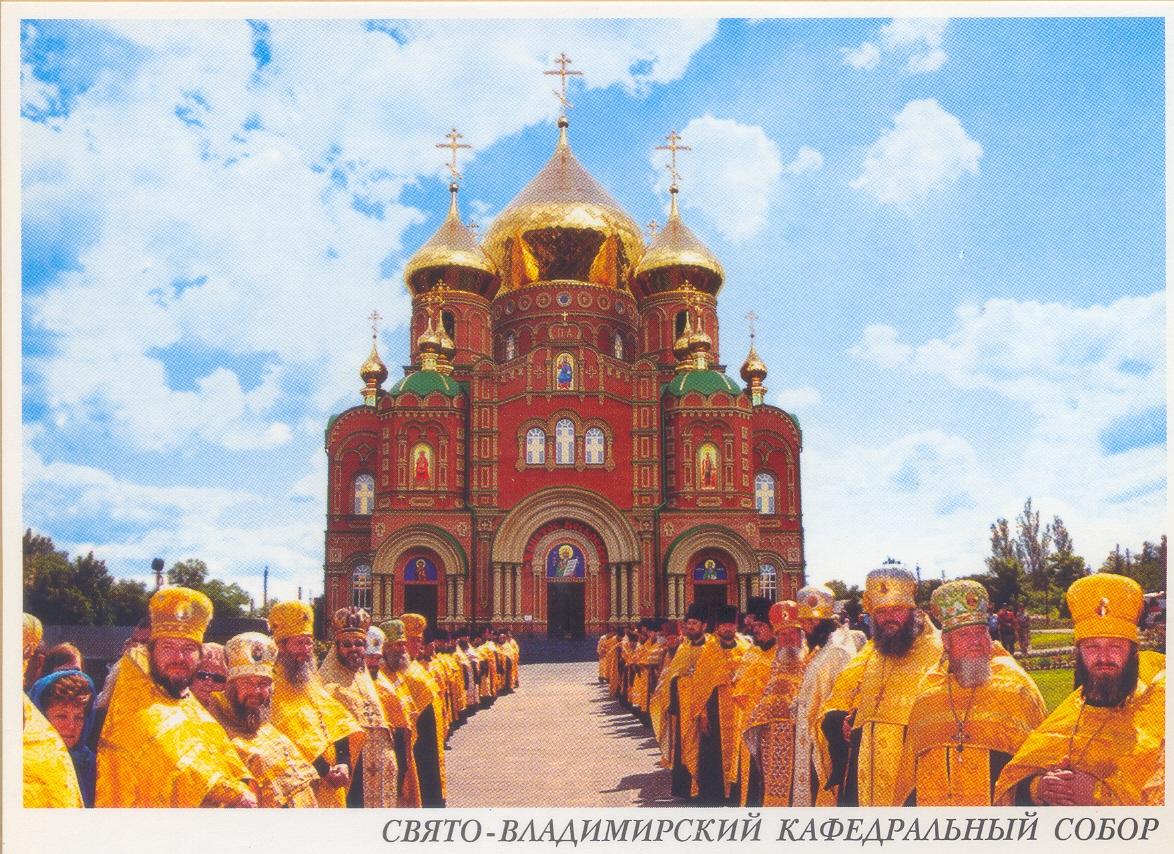
Luhansk (formerly Voroshilovgrad) also known as Lugansk is a city in southeastern Ukraine. It is the administrative center of the Luhansk Oblast (province). The city itself is also designated as its own separate municipality within the oblast. The current estimated population is around 445,900 (as of 2004). Luhansk is perhaps one of the few cities in the world that was renamed four times within 55 years. During the soviet times the city was called Voroshilovgrad in tribute of the Soviet military commander Kliment Voroshilov, a native of Luhansk, exactly since November 5, 1935, but on March 5, 1958, the old name Luhansk was reinstated until 1969. On January 5, 1970, after Voroshilov dead, the name of the city was changed again to Voroshilovgrad. On May 4, 1990, a decree of the Ukrainian SSR renamed again the city with its original name.
St. Vladimir Cathedral in Luhansk this unique structure. Its construction began in 1993, laying the first stone was with the former Ukrainian President Leonid Kuchma. Cathedral was solemnly consecrated on 19 March 2006. St. Vladimir Cathedral today is the biggest religious buildings in southeast Ukraine. The Cathedral can accommodate about 3 thousand parishioners. This lovely card was sent to me by Stanislav who lives in Luhansk.
Saturday, March 05, 2011
Ukraine – Varenyky
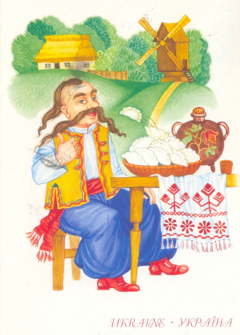
Varenyky or pierogi (Canadian Ukrainian), are a kind of stuffed dumpling associated with Ukrainian cuisine. Some variants are also found in Moldovan, Mennonite, Belarusian, Russian, Lithuanian, and Polish cooking. Varenyky are believed to originate from Chinese and Siberian influences, although sometimes they are said to be of Turkish origin. Varenyky are similar to Polish pierogi. Varenyky are square- or crescent-shaped dumplings of unleavened dough, stuffed with sauerkraut, cheese, mashed potatoes, cabbage, meat, hard-boiled eggs (a Mennonite tradition) or a combination of these, or with a fruit filling. Varenyky are very popular in Ukraine. This attractive card was sent to me by Roma.
Subscribe to:
Posts (Atom)