Welcome

Добро пожаловать к этому международному месту открытки изображения. Benvenuto a questo luogo internazionale della cartolina di immagine. Καλωσορίστε σε αυτήν την διεθνή περιοχή καρτών εικόνων. Willkommen zu diesem internationalen Abbildungspostkarteaufstellungsort. Bienvenue à cet emplacement international de carte postale. Onthaal aan deze Internationale plaats van de beeldprentbriefkaar. Welcome to this International picture postcard site. (Please Click on the Picture for an Enlarged View)

Sunday, March 31, 2013

Rotterdam - Experience one of the world's largest ports in all it's glory

You cannot visit Rotterdam, one of the largest harbours of the world, without seeing the harbours. The best way to see the harbours is making is a boattrip riding the Spido boats.
Among the busy traffic of sea-going and inland ships, this trip is a special journey through one of the largest harbours in the world. You can see Rotterdam's impressive skyline with its imposing buildings glide by, and then get a unique view of the harbours shipyards, docks and the hypermodern transshipping of thousands of containers. Last but not least the tour will end with a view of the steamship 'Rotterdam', the former cruise flagship of shipping company Holland America Line. An exciting 75 minutes with clear descriptions of everything you see.
When you go for a trip on this boat, you can eat as many pancakes as you like:-))

The trip takes about an hour and whike you are eating you can admire the Rotterdam Skyline. On Saturday night it is possible to have a moonlight cruise and of course eat as much as you like. 

The year round Spido offers various harbour trips. I made the regular boattrip of one and half hour through the port of Rotterdam, but there also trips of three or even six hours to the Botlek, Europoort and Delta Works.

From the boat you can have a good look at the spectacular skyline of the 'Manhattan on the Maas' with its impressive architecture. You will have nice views at the Erasmusbridge and the Willemsbridge, the hotel New York, the Euromast an other sights as well. Heading west you will reach the harbour areas with the docks and wharfs.

Thank you Marco for this lovely card and the info with it.

Saturday, March 30, 2013

The Brandenburg Gate

This friends is the Brandenburg Gate, famous all over the world. It is a former city gate and one of the main symbols of Berlin and Germany. It is located west of the city center at the junction of Unter den Linden and Ebertstraße, immediately west of the Pariser Platz. It is the only remaining gate of a series through which Berlin was once entered. One block to the north stands the Reichstag building. The gate is the monumental entry to Unter den Linden, the renowned boulevard of linden trees which formerly led directly to the city palace of the Prussian monarchs. 

It was commissioned by King Frederick William II of Prussia as a sign of peace and built by Carl Gotthard Langhans from 1788 to 1791. Having suffered considerable damage in World War II, the Brandenburg Gate was fully restored from 2000 to 2002 by the Stiftung Denkmalschutz Berlin (Berlin Monument Conservation Foundation). Today, it is regarded as one of Europe's most famous landmarks. 

Anke sent me this card during her recent visit to Berlin.

Friday, March 29, 2013

Besalú

Besalú  is a town in the comarca of Garrotxa, in Girona, Catalonia, Spain. The town's importance was greater in the early Middle Ages, as capital of the county of Besalú, whose territory was roughly the same size as the current comarca of Garrotxa but sometime extended as far as Corbières, Aude, in France. Wilfred the Hairy, credited with the unification of Catalonia, was Count of Besalú. The town was also the birthplace of Raimon Vidal, a medieval troubadour.
Besalú was designated as a historical national property ("conjunt històric-artístic") in 1966. The town's most significant feature is its 12th-century Romanesque bridge over the Fluvià river, which features a gateway at its midpoint. The church of Sant Pere was consecrated in 1003. The town features arcaded streets and squares and also a restored mikveh, a ritual Jewish bath dating from the eleventh or twelfth century, as well as the remains of a medieval synagogue, located in the lower town near the river. Besalú also hosts the Museum of miniatures created by jeweler and art collector Lluís Carreras.
The picture on the card shows an early-Medieval fortified masonry bridge crossing the river into the town of Besalu. Lina sent me this nice card.

Thursday, March 28, 2013

Homstead Guardians


Hanwen sent me this card from Taiwan. It depicts two "Homestead guardians" or door guardians as referred to by the locals in Lungci township, to ward of evil spirits from one's home.

Now, Lungci Township is a rural township of about 4,420 residents in Tainan County, Taiwan. 

Wednesday, March 27, 2013

River Daugava towards Old Riga


The photograph on the card was taken sometime in 1890. It shows shipping in the river Daugava towards old Riga. The River Daugava (in Latvian) or Western Dvina, not to be confused with Northern Dvina, is a river rising in the Valdai Hills, Russia, flowing through Russia, Belarus, and Latvia, draining into the Gulf of Riga in Latvia, an arm of the Baltic Sea. The total length of the river is 1,005 km (624 mi): 325 km (202 mi) in Russia, 328 km (204 mi) in Belarus, and 352 km (219 mi) in Latvia. In the 19th century, it was connected by a canal to the Berezina and Dnieper rivers (the canal is currently not functioning). The Daugava forms part of the international border between Latvia and Belarus.
Thank you Merja for this nice card.

Tuesday, March 26, 2013

Esko Salminen


Now, this card was issued along with the set of six stamps on contemporary Finnish stage and cinema actors on 4.3.2013. This card has a stamp featuring Esko Salminen. He is a Finnish actor with notable shows on TV and especially on stage. His parents were actors, so were his wives and children. Salminen has been an actor of the Finnish National Theatre since 1961. The stamp depicts him in the role of Shakespeare’s King Lear. In front of the Theatre Building you can see the Ice-park, located in the heart of Helsinki, next to the Central Railway Station.

Thank you Ella for this lovely card.

Monday, March 25, 2013

Modern Art in Austria


This maxi card commemorates Modern Art in Austria. It was sent to me by  Björn from Berlin. The card depicts a painting by Ernst Fuchs.
Ernst Fuchs (February 13, 1930 in Vienna). Ernst Fuchs is an Austrian painter, draftsman, print maker, sculptor, architect, stage designer, composer, poet, singer and one of the founders of the Vienna School of Fantastic Realism.

Saturday, March 23, 2013

Battle of the Chios Channel

This painting depicts the duel between the Turkish flagship Real Mustafa (84 guns) and Russian admiral Spiridov’s ship Svyatoy Evstafiy(68). During the boarding action the burning debris of the Turkish ship set the Russian flagship on fire and soon she blew up. The Russian admiral escaped the explosion just minutes before. Ten minutes later Real Mustafa exploded too. The Turkish squadron retreated to the Bay of Chesma only to be destroyed there in the next two days in what later to be called Battle of Chesma.
Ivan Aivazovsky was a Russian world-renowned painter living and working in Crimea, most famous for his seascapes, which constitute more than half of his paintings. Ivan Aivazovsky dedicated a number of his works to the Battle of the Chios Channel on the 24th of June 1770. This one was painted in 1848.

Thank you Polina for this lovely card.

Friday, March 22, 2013

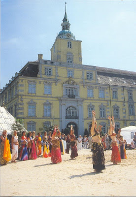
Oldenburg Palace

Oldenburg is an independent city in the state of Lower Saxony, Germany. During the French annexation (1811–1813) in the wake of the Napoleonic war against Britain, it was also known as Le Vieux-Bourg in French. The city is situated at the Rivers Hunte and Haaren, in the northwestern region between the cities of Bremen in the east and Groningen (Netherlands) in the west. It has a population of 162,173 (as of 2010), which makes it the fourth biggest city in Lower Saxony after Hanover, Braunschweig and Osnabrück. In German, the formal name isOldenburg (Oldenburg) or Oldenburg (Oldb) (spoken: Oldenburg in Oldenburg) to distinguish it from the city of Oldenburg in Holstein.
The city is the place of origin of the House of Oldenburg. Before the end of the German Empire (1918), it was the administrative centre and residence of the monarchs of Oldenburg.
The site of the splendid Oldenburg palace used to be the location of a moated castle. The palace as it now stands was built by Count Anton Günther (1583-1667). From 1607 to 1615 he had the medieval-style castle converted into a splendid Renaissance-style palace. From then on it served as the residence of all counts and grand dukes of the city.
The appearance of the palace also changed frequently in the following centuries. During the period of Danish rule from 1737 to 1753 the palace underwent a great deal of conversion work: The shape of the roof was changed, the tower entrance was closed and a main gate was built instead. In addition a north-east wing was built from 1774 to 1778. It served to house the Danish governor and minister Friedrich Lewin Graf Holmer. Duke Friedrich August probably named this wing the "Holmerflügel" after him. His successor Duke Peter Ludwig had the two-floor "library wing" built and had the inside of the palace refurbished by the court painter Heinrich Wilhelm Tischbein (1751-1829) in a classicist style. In 1894 the dilapidated "Kanzlei-Flügel" was torn down.
Since 1921 the Oldenburg palace has been part of the Federal State Museum for Art. The square in front of the castle is often used as a meeting place for different cultures as depicted on the card. Thank you Marco.

Thursday, March 21, 2013

Historic Post Offices

On 3rd February 1987 the GDR issued four stamps commemorating four historic post offices in East Germany. Along with the stamps a maximum card depicting each of these post offices was also issued. The maxi cards shown here portray the post offices atWeimar which was established in 1888/89, and the one at Kirchau in 1924/26. The other two post offices were at Freiberg and Perleberg.
Marco sent me these nice maxicards.
 

Wednesday, March 20, 2013

Struve chain

In Korpilahti, at the top of Oravivuori, lies one of Finland's six points in the Struve chain. This is a triangulation chain extending from the Black Sea to the Arctic Ocean that was used in the 19th century to establish the shape of the earth. On this spot a triangulation tower has been erected to commemorate the importance of the Oravavuori (or Puolakka) measuring station to the mapping of Finland. Struve's chain gained inclusion on the UNESCO world heritage list in 2005. Thank you dear Ella for this interesting card.


Tuesday, March 19, 2013

Christina Alexandra - Queen regnant of Sweden


Christina (18 December 1626 – 19 April 1689), later adopted the name Christina Alexandra, was Queen regnant of Sweden from 1633 to 1654, using the titles of Queen of Swedes, Goths and Vandals, Grand Princess of Finland, and Duchess of Ingria, Estonia, Livonia and Karelia. She was the only surviving legitimate child of King Gustav II Adolph and his wife Maria Eleonora of Brandenburg. As the heiress presumptive, at the age of six she succeeded her father on the throne of Sweden upon his death at the Battle of Lützen. Being the daughter of a Protestant champion in the Thirty Years' War, she caused a scandal when she abdicated her throne and converted to Roman Catholicism in 1654. She spent her later years in Rome, becoming a leader of the theatrical and musical life there. As a queen without a country, she protected many artists and projects. She is one of the few women buried in the Vatican grotto.
Christina was moody, intelligent, and interested in books and manuscripts, religion, alchemy and science. She wanted Stockholm to become the Athens of the North. Influenced by the Counter Reformation, she was increasingly attracted to the Baroque and Mediterranean culture that took her away from her Protestant country. Her unconventional lifestyle and masculine dressing and behaviour would feature in countless novels and plays, and in opera and film.
These two cards show two views of the coronation pageantry. The First card shows Mars with his three knights in a tableau vivant. And the second card depicts Amor and Venus in a self-propelling carriage. The original paintings are in the National Museum in Finland. Thank you Dear Merja for these very interesting cards.

Monday, March 18, 2013

Dutch Fleet at Anchor


A lovely painting of the Dutch Fleet of the 1800's at anchor.

Sunday, March 17, 2013

USS Missouri Memorial


USS Missouri (BB-63) ("Mighty Mo" or "Big Mo") is a United States Navy Iowa-class battleship and was the third ship of the U.S. Navy to be named in honour of the US state of Missouri. Missouri was the last battleship built by the United States and was the site of the surrender of the Empire of Japan which ended World War II.
Missouri was ordered in 1940 and commissioned in June 1944. In the Pacific Theatre of World War II she fought in the battles of Iwo Jima and Okinawa and shelled the Japanese home islands, and she fought in the Korean War from 1950 to 1953. She was decommissioned in 1955 into the United States Navy reserve fleets (the "Mothball Fleet"), but reactivated and modernized in 1984 as part of the 600-ship Navy plan, and provided fire support during Operation Desert Storm in January/February 1991.
Missouri received a total of 11 battle stars for service in World War II, Korea, and the Persian Gulf, and was finally decommissioned on 31 March 1992, but remained on the Naval Vessel Register until her name was struck in January 1995. In 1998, she was donated to the USS Missouri Memorial Association and became a museum ship at Pearl Harbour, Hawaii. 

Thank you Duncan for this wonderful card.


Saturday, March 16, 2013

The Archipelago Trail


Saaristotie in Finnish means Archipelago road in English. This Finnish national road 180 (regional road 180) runs from Kaarina to Korppo (Korpo) via Parainen (Pargas) and Nauvo (Nagu).
Archipelago Sea is a part of the Baltic Sea between the Gulf of Bothnia, the Gulf of Finland and the Sea of Aland , within Finnish Territorial waters . By some definitions it contains the largest archipelago (island group) in the world by the number of islands, although many of the islands are very small and tightly clustered.
The larger islands are inhabited and connected by ferries and bridges. The Aland Islands, including the largest islands of the region, form an autonomous region within Finland. The rest of the islands are part of province of Southwest Finland. The Archipelago Sea is a significant tourist destination.

Several of the islands have been developed for tourism. Accommodation facilities ranging from exclusive and luxurious beach villas to the more common simple sports cabins with good fishing opportunities are available. Several of the islands have been developed to provide coastal facilities.  

The Archipelago Trail. The Archipelago Ring Road allows travellers to access the archipelago by car, bus or boat. The circular route of the Archipelago Trail, even though only approximately 250 kilometres in length, offers a surprising number of varied experiences. During your trip from one island to another, you will experience various ferries and vessels.

Yes, indeed Ella, a holiday for tourists here would just be wonderful!

Friday, March 15, 2013

Provence


Provence is a region of south eastern France on the Mediterranean adjacent to Italy. It is part of the administrative region of Provence-Alpes-Côte d'Azur. The traditional region of Provence comprises the départements of Var, Vaucluse, Bouches-du-Rhône, Alpes-de-Haute-Provence, Alpes-Maritimes and parts of Haues-Alpes. The important places in this region are shown on the card. The Romans made the region into the first Roman province beyond the Alps, their Provincia Romana, the origin of its present name.
Christiane who lives in this region sent me this card.

Thursday, March 14, 2013

Sammallahdenmäki - Bronze age burial site

Sammallahdenmäki is a Bronze age burial site in Finland in Lappi municipality. It was designated by UNESCO as a World Heritage Site in 1999, and includes 36 granite burial cairns dating back more than 3,000 years, to 1,500 to 500 BC. It is located on a hill in a remote area off the road between Tampere and Rauma. Originally, it was near the coast of the Gulf of Bothnia, but the land has risen so it is now 15 kilometers from the sea. It is one of the most important Bronze Age sites in Scandinavia.
Four of the cairns were excavated by archaeologist Volter Högman in 1891, including Kirkonlaattia ("Church Floor"), an unusual rectangular cairn covering 16 x 19 metres with a flat top, and Huilun pitkä raunio ("long ruin of Huilu"), which is surrounded by an ancient stone wall.
The Bronze Age cairn cemetery of Sammallahdenmäki in Lappi was the first Finnish archaeological site to be included in the UNESCO World Heritage List in December 1999. Sammallahdenmäki was chosen to the list as the finest Western Bronze Age site in Finland and Scandinavia.
Thank you Ella for this card.

Wednesday, March 13, 2013

Aphrodite's Baths

Akamas, is a promontory and cape at the northwest extremity of Cyprus area of 230 square kilometres. Ptolemy described it as a thickly wooded headland, divided into two by summits [a mountain range] rising towards the north. The peninsula is named after a son of Theseus , hero of the Trojan War and founder of the city-kingdom of Soli.
Until the year 2000, the peninsula was used by the British Army and Navy for military exercises and as a firing range. Under the 1960 Treaty of Establishment, the British Army was allowed to use the Akamas for exercises for up to 70 days a year. 
At the southern end of the peninsula is the town of Pegeia and on its northeast side the town of Polis.
Due to the mountainous nature of the peninsula there are no roads running through its heartland. Furthermore some roads marked on Cypriot road maps of the area are not tarmaced. Visitor attractions in Akamas include a loggerhead turtle sanctuary and the Baths of Aphrodite where the goddess is said to have bathed, near Polis. As the area is therefore relatively inaccessible, there is a large diversity of flora and fauna there. Indeed the European Environment Agency noted that it was one of only 22 areas of endemism in Europe. This however looks like it may be threatened by tourist development and the planned A7 motorway between Polis and  Paphos; organisations such as the Green Party of Cyprus, Greenpeace and Friends of the Earth are taking action to protect the area.
This natural beauty spot is steeped in the myths and legends of Cyprus. Set in a pool grotto, surrounded by greenery, the site is said to be the place where Aphrodite, goddess of Love, bathed. According to local folktale, bathing in the pools water, could reduce your age by about 10 years, although eels have been placed in the water in the past to stop people from getting in the water. Legend also has it that Aphrodite met her most famous lover, Adonis at this spring. Thank you Merja for this pretty card. Lucky Adonis ;-))

Tuesday, March 12, 2013

Church of Petäjävesi


These two cards show the two views of this famous church in winter and in summer. The Petäjävesi Old Church is a wooden church located in Petäjävesi, Finland. It was built between 1763 and 1765. The bell tower was built in 1821. It was inscribed in 1994 on the UNESCO World Heritage List.
The church is located about 1 km to the west of the centre of Petäjävesi. The church went out of use in 1879 when the new church was built. The old church has retained its original appearance and its interior decoration exceptionally well. It is a popular church for weddings in the summer, and there is a church service on most Sundays.
The church was built as the chapel for the area of Petäjävesi, which has belonged to the congregation of Jämsä. The local people had been given the permission to build a graveyard and a small village church at their own expense by the crown as early as in 1728 because the trip to Jämsä was long, howewer it took about 35 years until the construction began. The church was planned and built by Jaakko Klemetinpoika Leppänen, a church builder from Vesanka. In 1821 the windows were enlarged and the sacristy was moved from the northern part of the church to the east. The bell tower was also added by Erkki Leppänen, the grandson of the original builder.
After the new church was built, the old remained abandoned for a long time. Only the cemetery around the church and the belltower were in use. In the 1920's an Austrian art historian Josef Strzygowski noticed the architectural and historical value of the church and since 1929 it has been restored several times. In 1994 it was approved in the UNESCO's World Heritage Sites representing typical eastern Scandinavian wooden church tradition.
Thank you Ella for these lovely cards.

Monday, March 11, 2013

James Bond

One of the most famous scenes in the James Bond series is the golf match in Goldfinger. The wine-coloured V-neck sweater is the main piece here, with it’s yellow Slazenger panther logo on the chest. Underneath the sweater Bond wears a light grey long-sleeve polo shirt. Bond’s trousers are wool with frogmouth pockets. I’m not certain, but believe the trousers are navy blue. Bond has a red and white glove for his left hand, and when he isn’t golfing he sticks it in his left pocket. The shoes are brown kiltie Norwegian derbies with metal cleats on the sole. Bond’s hat is a grey straw trilby with a narrow brim, C-crown and front pinch. The large hat ribbon is black with 2 bands of white and red stripes. This was a very nice description of James Bond as he strokes his way to a win over Goldfinger. This wac courtesy  Matt Spaiser a graphic designer located in New York.
The card shown was sent to me by Lothar.

Sunday, March 10, 2013

Bellapais Abbey

My friend Merja sent me this nice card about the Bellapais Abbey in Cyprus. Now, Bellapais is a small village in the Turkish-controlled Northern Cyprus, about four miles from the town of Kyrenia. The village was the home for some years ofLawrence Durrell, who wrote about life in Cyprus in his book Bitter Lemons. He mentions passing the time drinking coffee under the Tree of Idleness in the village and there are two places which lay claim to being the spot. Unfortunately his book did not identify it completely, or perhaps fortunately, because two establishments can now profit from the name. His house, up a very steep climb, has a plaque on it and one can have the pleasure of returning by a not-quite-so-perpendicular way that passes by old olive presses.
The jewel of the village is Bellapais Abbey or "The Abbey of Peace”. Built by canons  regular of the Premonstratensian Order in the 13th century, it is a most imposing ruin in a wonderful position commanding a long view down to Kyrenia and the Mediterranean Sea.
Most of the monastic buildings surround the cloister. In Britain these would normally be built on the south side of the church so to some extent protect the living quarters from the cold air from the north. At Bellapais, the monastic buildings are on the north, probably to be cooler, although occasionally the lay of the land dictated position.
Today the site is a museum, which also hosts a restaurant and a cafe.

Saturday, March 09, 2013

Suomenlinna - World Heritage Site

In 1991, the Suomenlinna fortress was added to the UNESCO World Heritage List as a unique monument of military architecture. Other World Heritage Sites include the pyramids of Giza and the Great Wall of China. Suomenlinna is one of Finland’s most popular tourist attractions. At the same time it is a suburb of Helsinki, with 850 people living in the renovated ramparts and barracks.
Suomenlinna is unique in that although it is a bastian fortress, it is irregular in shape as a result of being built on a cluster of rocky islands with highly variable terrain, requiring a very free adaptation of the theory of fortifications developed in central Europe. The Suomenlinna World Heritage Site currently includes seven islands.
Another special feature of the fortress is that in the course of its history it has served in the defence of three realms: Sweden, Russia and Finland. Moreover, it continues to be a living, tended and inhabited district of the city of Helsinki.
Suomenlinna is to a large extent historically authentic, i.e. consisting of original structures. Several significant layers of historical development in fortifications and shipyards may be seen on Suomenlinna. The dry dock  at the heart of the fortress, with galley basin, lock gates and paternoster device, was the state of the art in 18th-century technology. There are also dozens of historical underwater sites around the fortress.

Thank you Ella for this nice card.

Friday, March 08, 2013

Illinois


Far from the hustle and bustle of the third largest city in the USA, Illinois small towns and rural areas beckon visitors with their changing seasons, prairie lands, and crops. The round silo for farm storage was first constructed on a farm in Spring Grove, IL. Corn, soyabeans, wheat, oats, barley, rye and sorghum are the leading crops. Cattle is a major industry in Illinois.
Thank you Frank for sending me this lovely card.

Thursday, March 07, 2013

The Rhur

This card showing different scenes in the Ruhr region of Germany was sent to me by Katija. The Rhur is an urban area in North Rhine-Westphalia, Germany.
With a population density of 2,800/km² and a population of some five million, it is the largest urban agglomeration in Germany. It consists of several large, industrial cities bordered by the rivers Ruhr to the south, Rhine to the west, and Lippe to the north. In the Southwest it borders the Bergisches Land. It is considered part of the larger Rhine-Ruhr metropolitan region of more than 12 million people.
From west to east, the region includes the cities of Duisburg, Oberhausen, Bottrop, Mülheim an der Ruhr, Essen, Gelsenkirchen, Bochum, Herne, Hagen, Dortmund, and Hamm, as well as parts of the more "rural" districts of Wesel, Recklinghausen, Unna and Ennepe-Ruhr-Kreis. Historically, the western Ruhr towns, such as Duisburg and Essen, belonged to the historic region of the Rhineland, whereas the eastern part of the Ruhr, including Gelsenkirchen, Bochum, Dortmund and Hamm, were part of the region of Westphalia. Since the 19th century, these districts have grown together into a large complex with a vast industrial landscape, inhabited by some 7.3 million people  (including Düsseldorf and Wuppertal).
It is the fifth largest urban area in Europe after Istanbul, Moscow, London and Paris.
For 2010, the Ruhr region was one of the European Capitals of Culture.

Wednesday, March 06, 2013

Glen Helen Gorge

Glen Helen (including Ormiston Gorge and Pound National Park). One of the most beautiful gorges in Central Australia. Glen Helen is located 133 km west of Alice Springs at the end of the sealed section of road known as Namatjira Drive. No one knows who named the region but it was one of the first pastoral leases in Central Australia. The first owner, Alan Braeden, overlanded stock over 2000 km and built a house, Munga Munga, on the bank of Ormiston Creek. It is now nothing more than a pile of rubble.
Today the term Glen Helen is applied to the lodge, the gorge near the lodge and the surrounding 368 hectare Nature Park controlled by the Conservation Commission of the Northern Territory. The Glen Helen Gorge is formed from quartzite. Sandstone was deposited in the area some 500 million years ago when it was a huge inland sea. It was subsequently tilted and uplifted. As this uplift was occurring the Finke River slowly eroded its way through the mountain range. Glen Helen is known to local Aborigines as Yapalpe and the Finke River is Larapinta which means 'serpent'. It was a favourite meeting place for the Aboriginal people from the West and Central MacDonnell Ranges. The rocky slopes around the gorge are home to a colony of black-footed rock wallabies which sometimes appear in the late afternoon and early evening to feed on grass, herbs, leaves and fruits.
The Finke River, which was named by John McDouall Stuart after the Adelaide financier William Finke, rises in the MacDonnell Ranges and flows over 1000 km until it disappears into Lake Eyre. Over the years the Finke has acquired its own mythology. Rumours about it abound. It is claimed, even in the Conservation Commission literature, that the Finke is the oldest river in the world - no one quite explains what such a claim actually means. It certainly isn't recorded as such in the Guinness Book of Records. It is said that the Finke only ever runs for the entire length of its course about twice every century. Glen Helen is one of only six permanent waterholes on the Finke River. A tributary of the Finke, the Ormiston Creek, runs through Ormiston Gorge and Pound National Park. The park consists of the spectacular Pound and the narrow gorge which is regarded by many as one of the most beautiful gorges in Central Australia. The subject of a number of paintings by Albert Namatjira the gorge rises to over 300 metres at points and is characterised by the beautiful river red gums and the euros and rock wallabies which abound in the park.
The area was explored by Peter Egerton Warburton on his epic 1873-74 journey from Alice Springs to the Western Australian coast which traversed the Great Sandy Desert. He named the Ormiston Creek which runs through the area and joins the Finke River.
Thank you Dear Heather for this lovely card and the wonderful stamps on it.

Tuesday, March 05, 2013

Diamond Shoals,

Diamond Shoals, which extend many miles out from Cape Hatteras, is considered to be one of the most dangerous spots on the Atlantic seaboard. While a light was exhibited from the cape itself from 1804, its range was insufficient, and a lightship was stationed on the shoal itself in 1824. It was driven off station numerous times, eventually being wrecked near Ocracoke Inlet in 1827. Various buoys were placed beginning in 1852, but all were short-lived.  lightship, LV 69, was the first of six lightships employed at Diamond Shoals in the twentieth century. Prior to World War I, lightships were assigned in pairs at this station, which each relieving the other; after LV 71 was sunk by the German submarineU-104, a single ship was assigned, relieved as needed. During World War II the lightship was replaced by a lighted buoy. The last lightship stationed here, WLV 189, was the first lightship built after the Coast Guard took over the Lighthouse Service, and the first all-welded lightship; it was expressly built for service at this station, and remained in service there until 1966.
The card shows a watercolour painting of the Diamond” Shoal by Winslow Homer.
Winslow Homer (February 24, 1836 – September 29, 1910) was an American landscape painter and printmaker, best known for his marine subjects. He is considered one of the foremost painters in 19th-century America and a preeminent figure in American art. Largely self-taught, Homer began his career working as a commercial illustrator. He subsequently took up oil painting and produced major studio works characterized by the weight and density he exploited from the medium. He also worked extensively in watercolor, creating a fluid and prolific oeuvre, primarily chronicling his working vacations.
Carol who sent me this card also affixed some very historic stamps on it. They relate to the US Civil Rights, Fort Sumter in South Carolina and was the scene of the First Battle of the war. The stamp regarding the Emancipation Proclamation which freed slaves from their bondage. Rosa Parks was a Civil Rights pioneer and activist.

Monday, March 04, 2013

Rotterdam

Rotterdam is the second-largest city in the Netherlands and one of the largest ports in the world. Starting as a dam constructed in 1270 on the Rotte River, Rotterdam has grown into a major international commercial centre. Rotterdam is the second-largest city in the Netherlands and one of the largest ports in the world. Starting as a dam constructed in 1270 on the Rotte River, Rotterdam has grown into a major international commercial centre. Its strategic location at the Rhine-Meuse-Scheldt delta on the North Sea and at the heart of a massive rail, road, air and inland waterway distribution system extending throughout Europe is the reason that Rotterdam is often called the "Gateway to Europe". In the province of South Holland, Rotterdam is in the west of Netherlands and the south of the Randstad. The population of the city was 616,250 on February 1, 2012. The population of the greater Rotterdam area, called "Rotterdam-Rijnmond" or just "Rijnmond", is approximately 1.3 million. The combined urban area of Rotterdam and The Hague is the 206th largest urban area in the world. One of Europe's most vibrant, multicultural cities, Rotterdam is known for its university (Erasmus), cutting-edge architecture, lively cultural life, striking riverside setting and maritime heritage. It is also known for the Rotterdam Blitz. The largest port in Europe and one of the busiest ports in the world, the port of Rotterdam was the world's busiest port from 1962 to 2004, when it was surpassed by Shanghai. Rotterdam's commercial and strategic importance is based on its location near the mouth of the Niew Meuse (New Meuse), a channel in the delta formed by the Rhine and Meuse on the North Sea. These rivers lead directly into the centre of Europe, including the industrial Ruhrregion.

Also seen on the card is the Erasmus Bridge which is a cable-stayed bridge across the Nieuwe Maas, linking the northern and southern regions of Rotterdam.  The Erasmus Bridge was designed by Ben van Berkel and completed in 1996. The 802-metre-long (2,631 ft) bridge has a 139-metre-high (456 ft) asymmetrical pylon, earning the bridge its nickname of "The Swan". The southern span of the bridge has an 89-metre-long (292 ft) bascule bridge for ships that cannot pass under the bridge. The bascule bridge is the largest and heaviest in West Europe and has the largest panel of its type in the world. After costing more than 163 million euros to construct, the bridge was officially opened by Queen Beatrix on September 6, 1996.[1] Shortly after the bridge opened to traffic in October 1996, it was discovered the bridge would swing under particularly strong wind conditions. To reduce the trembling, stronger shock dampers were installed.
The Bridge has been used during many memorable events. The bridge featured in the 1998Jackie Chan film "Who Am I?" In 2005, several planes flew underneath the bridge as part of the "Red Bull Air Race". In 2005, the bridge served as the backdrop for a performance by DJ Tiësto titled "Tiësto @ The Bridge, Rotterdam". The performance featured fire-fighting ships spraying jets of water into the air in front of the bridge, a fireworks barge launching fireworks beside the bridge, and multi coloured spot/search lights attached to the bridge itself. The bridge was crossed during the prologue and the opening stage of the 2010 Tour de France.
Thank you Marco for this nice card.

Sunday, March 03, 2013

Lake Päijänne

Lake Päijänne is the second largest lake in Finland lake (1,080 km2 (266,874 acres)). The lake drains into the Gulf of Finland via the Kymi River. The major islands are from north to south Vuoritsalo, Muuratsalo, Onkisalo, Judinsalo, Edessalo, Taivassalo, Haukkasalo, Vehkasalo, Mustassalo, Virmailansaari and Salonsaari. The largest island is Virmailansaari. The word saari means an island. Salo meant before a great island, nowadays it means a great forest area.
Largest city on the shores of Päijänne is Jyvaskyla in the North. The city of Lahti is connected to Päijänne through Lake Vesijärvi and Vääksy canal. An underground, Päijänne Water Tunnel, connects the lake to Helsinki, providing the capital area with water. The deepest point in any lake in Finland is located in Päijänne (95.3 m).
That Päijänne is a famous boating, canoeing and sailing attraction is well portrayed by the sailing enthusiasts in the picture on this card sent to me byHeli. 

Friday, March 01, 2013

North Sea seal


The North Sea is home to marine mammals. Common seals, and Harbour porpoises can be found along the coasts, at marine installations, and on islands. The very northern North Sea islands such as the Shetland Islands are occasionally home to a larger variety of pinnipeds including bearded, harp, hooded and ringed seals, and even walrus. North Sea cetaceans include various porpoise, dolphin and whale species.
A virus, which cost the lives of 18,000 seals on Germany's North Sea coast in 1988 has turned up on German shores again this week. It poses a fatal threat to the seals and ecology of Europe’s unique North Sea mud flats.

The North Sea seal population is in serious danger The seal is a sociable animal. But the creature's friendly habits are now costing it its life. Experts say that viruses have little trouble spreading fast among seal populations.
Indeed, in 1988, the Phocine Distemper Virus (PDV) cost the lives of 18,000 seals on Germany’s North Sea cost, effectively wiping out some 60 per cent of the area’s seal population. There are now fresh signs that the environmental nightmare is seeing an unwelcome revival. The first dead seals with the lethal virus were discovered two months ago in Kattegat, just off the Danish island Anholt. Since then 2000 animals have fallen victim to the deadly disease off the Scandinavian coast, and the first five infected seals were washed up on German shores this week.
The present crisis is almost a repitition of the virus-outbreak scenario, 14 years ago. The 1988 epidemic, the first to have been reported since researchers counted some 37,000 seals living in the North Sea’s mud flats back in 1900, was sparked by arctic seals. They are believed to have been suffering from Russian and Scandinavian overfishing and looking for nutrition way beyond the boundaries of their natural habitat.
The PDV virus befalls lungs and respiratory organs and bacterial infections bacteria follow. As parasites spread easily to other body organs, the seal dies a slow, and painful death. While arctic seals are able to live with the PDV virus, the North Sea seal’s population are defenceless against this relatively new epidemic, as they lack the necesary antibodies. In addition, weakened by a steady increase in marine pollution, these animals now stand little chance of survival.
Thank you Joachim for this card, because such seals may be extinct soon.