Thursday, June 28, 2012


The River Mersey is a river in North West England. It is around 70 miles (113 km) long, stretching from Stockport, Greater Manchester, and ending at Liverpool Bay, Merseyside. For centuries, it formed part of the ancient county divide between Lancashire and Cheshire.
The river is now internationally famous thanks to the music of the 1960s known as Mersey beat and its strong association with Liverpool, which produced songs such as "Ferry Across The Mersey".
Over 30 acres of land within the heart of the Liverpool dock area. The site is a paradise to bird watchers and is an important area for seabirds and waders. Consisting of freshwater and salt lagoons it also provides a valuable source of food for the ducks that over-winter in Liverpool. For those interested in viewing the wildlife, three viewing hides are available for use, in one of the freshwater lagoons. Ross sent me this nice card.

Wednesday, June 27, 2012

Shipwreck (1854) by Ivan Aivazovsky


Throughout his lifetime, Ivan Aivazovsky contributed over 6,000 paintings to the art world, ranging from his early landscapes of the Crimean countryside to the seascapes and coastal scenes for which he is most famous. Aivazovsky was especially effective at developing the play of light in his paintings, sometimes applying layers of color to create a transparent quality, a technique for which they are highly admired.
Although he produced many portraits and landscapes, over half of all of Aivazovsky’s paintings are realistic depictions of coastal scenes and seascapes. He is most remembered for his beautifully melodramatic renditions of the seascapes of which he painted the most. Many of his later works depict the painful heartbreak of soldiers at battle or lost at sea, with a soft celestial body taunting of hope from behind the clouds. His artistic technique centers on his ability to render the realistic shimmer of the water against the light of the subject in the painting, be it the full moon, the sunrise, or battleships in flames. Many of his paintings also illustrate his adeptness at filling the sky with light, be it the diffuse light of a full moon through fog, or the orange glow of the sun gleaming through the clouds.

This painting is a testament to the artist’s skill of portraying light and dark. With nothing more than a pencil and gouache on paper, this scene illustrates the strong winds and crash of the waves with violent intensity. This intensity makes you fear for the safety of the standing observers, as if the waves threaten to dash the ship against the cliff, upon which they are standing, and throw them into the sea. Three seagulls fly over the ship, creating the slight sense that all hope is not lost, and seeming as if is not impossible to hope that the ship may not yet be lost.
This lovely card was sent to me by Rita from Kaliningrad in Russia.

Tuesday, June 26, 2012

The Hallig


The North Frisian Hallig Islands are indeed unique in the world. The Halligen (singular Hallig) are ten small German islands without protective dikes in the North Frisian Islands on Schleswig-Holstein's Wadden Sea-North Sea coast in the district of Nordfriesland. The name comes from a Celtic word hal, meaning "salt", a reference to the low-lying land in the region which is often flooded over with saltwater by the tides. A greater number of Halligen existed in the Middle Ages than in the 21st century. The very existence of the Halligen is a result of frequent floods and poor coastal protection. The floods were much more common in the Middle Ages and coastal protection was much poorer. A look at the maps on this page will demonstrate that this part of the North Sea coast is very much at the sea's mercy.
The Halligen have areas ranging from 7 to 956 ha, and are often former parts of the mainland, separated therefrom by storm tide erosion. Some are also parts of once much bigger islands sundered by the same forces. Sometimes, owing to sediment deposition, islands have actually grown together to form larger ones. Langeneß (or Langeness) includes a former island by that same name, and two others that were called Nordmarsch and Butwehl. Dwellings and commercial buildings are built upon metre-high, man-made hills, called Warften in German, to guard against storm tides. Some Halligen also have overflow dikes. Not very many people live on the Halligen. Their livelihoods are mainly based on tourism, coastal protection, and agriculture. This last activity mainly involves raising cattle in the fertile, often flooded, salt meadows.
Sabine sent me this card which has a painting of a Hallig.

Monday, June 25, 2012

Swiss Quality Emblem


This "maximum card" of Switzerland, showing the commemorative stamp of 40 cents denomination commemorating 50 years of "Swiss Quality Emblem (showing traditional "Armbrust" (Crossbow), with  which William Tell had killed "Gestler", who according to legend put an apple on the head of the son of William Tell and ordered the father (William Tell) to shoot the
apple, you certainly know the legend! The Swiss people believe in the legend, but there is not a single person called "Tell" who lived in the past or is living in Switzerland today!). The emblem (Trademark) Armbrust was introduced for the first time in 1931.This Armbrust Signet ensures the buyers that the product which they have purchased is genuine, and is made in Switzerland. In 1981 this signet celebrated its 50th anniversary. Thank you Maria for this interesting maxicard.

Saturday, June 23, 2012

Niasvizh Catholic Corpus Christi church


Nesvizh is a city in Belarus. It is the administrative centre of the Nesvizh District (rajon) of Minsk Province and location of the Nesvizh Castle World Heritage Site. Its 2009 population was 14,300.
Niasvizh Catholic Corpus Christi church was built in 1587–1593 according to the design of the Italian architect Jovanni Maria Bernardoni at sponsorship of Mikolai Christopher Radziwill the Orphan. The Jesuit church in Niasvizh was the first construction in Baroque in the whole territory of Rzecz Pospolita. The temple interior is richly decorated with paintings. The frescoes were performed in 1750–60-s with participation of the artist K.D. Gesski (restored in 1900–1902). The frescoes embrace 40 individual compositions depicting Saints, allegorical scenes and biblical stories. The fresco compositions include cartouches with the Bible stanze and references. There is K.D. Gesski’s picture "The Lord's Supper" (1753) in the main shrine. In addition to the paintings, the church interior contains a lot of plastic images, i.e. bás-reliefs and bust gravestones of the 17th – 19th centuries, marble altars and monuments. There is a choir with an organ above the temple entrance. An entrance into the family crypt – a burial vault of the Radziwills – is located next to the bás-relief under the altar of Christ. There are over seventy burials of the mighty dynasty in the semi-basement.
My friend Eugenia sent me this nice postcard.

Friday, June 22, 2012

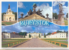
Branicki Palace, Białystok


Białystok is the largest city in northeastern Poland and the capital of the Podlaskie Voivodeship. Located in the North Podlasie Lowland on the banks of the Biała River, Białystok ranks second in terms of population density, eleventh in population, and thirteenth in area, of the cities of Poland. It has historically attracted migrants from elsewhere in Poland and beyond, particularly from Central and Eastern Europe. This is facilitated by the fact that the nearby border with Belarus is also the eastern border of the European Union, as well as the Schengen Area. The city and its adjacent municipalities constitute Metropolitan Białystok. The city has a Warm Summer Continental climate, characterized by warm summers and long frosty winters. Forests are an important part of Białystok's character, and occupy around 1,756 ha (4,340 acres) (17.2% of the administrative area of the city) which places it as the fifth most "wooded" city in Poland.
Branicki Palace is a historical edifice in Białystok, Poland. It was developed on the site of an earlier building in the first half of the 18th century by Jan Klemens Branicki, a wealthy Polish–Lithuanian, into a residence suitable for a man whose ambition was to become king of Poland. The palace complex with gardens, pavillons, sculptures, outbuildings and other structures and the city with churches, city hall and monastery, all built almost at the same time according to French models was the reason why the city was known in the 18th century as Versailles de la Pologne (Versailles of Poland) and subsequently Versailles de la Podlachie (Versailles of Podlachia)
With the first Partition of Poland it went to the Prussian Kingdom and, after 1807, to Russia. In the summer of 1920, briefly, the palace was the headquarters of the Provisional Polish Revolutionary Committee. Branicki Palace suffered from bombing and fires caused by the Germans, with damage totalling approximately 70%. It was restored after World War II as a matter of national pride. The Medical University is now housed in the Palace. Justyna a resident sent me this card.

Thursday, June 21, 2012

Thoughts for the Day


My friend Merja sent me these two cards. I thought they were very good, and felt like sharing them with you. I agree with both of them, but I liked the Chocolate one better ;-))

Wednesday, June 20, 2012

World’s Most Modern Car


It was the 1940 Oldsmobile sedan. And they called it the World’s Most Modern Car. And why not! Automatic transmission was based on technology first developed in the early 1900s by German manufacturers of marine engines. However, it was not adapted for automobiles for several decades. In 1938, General Motors developed the first line of cars to sport automatic transmission -- Oldsmobiles that offered "Hydra-Matic drive." The cars were introduced to the public in 1940. In 1941, Chrysler followed suit and introduced three different cars that offered their version of automatic drive, "Vacamatic" (later called "Fluid Drive"). Automatic transmission was a fairly common option on most American cars by 1948. It provided true clutchless driving with four forward speeds. Its fluid coupling between engine and transmission eliminated the clutch and its associated foot work. Olds made the breakthrough Hydra-Matic available on all models for only an extra $57. This lovely card. A vintage one really, was sent to me by Tina from China.

Tuesday, June 19, 2012

Winter Warfare in Finland


This card shows a picture of a pair of Finnish soldiers at a Winter Training Camp in North Lappland.  Forget about training or actual operations, even living and existing in those sub-zero temperatures must be an extreme ordeal. But, military history books are replete with the glorious exploits of the outnumbered Finnish soldier on skis against heavy odds. And in most cases the soldiers fighting the Finns had a bloody nose. Margaretha sent me this card. The picture on it was taken by her son who is in the Finnish Army.

Monday, June 18, 2012

ASW&C Wedgetail


Four New Stamps to Commemorate 90 Years of RAAF were issued on 22.2.2011. The four Air Force Aviation stamps feature the F-111 (60 cents), the F/A-18F Super Hornet (60 cents), the AEW&C Wedgetail ($1.20) and the C-17 Globemaster III ($3.00). This good maxicard sent to me by Vikki features the Wedgetail.
The Boeing 737 AEW&C is a twin-engine airborne early warning and control aircraft. It is lighter than the 707-based Boeing E-3 Sentry, and mounts a fixed, electronically scanned, rather than a rotating, radar antenna. It was designed for the Royal Australian Air Force (RAAF) under "Project Wedgetail". The 737 AEW&C has also been selected by the Turkish Air Force, the Republic of Korea Air Force, and has been proposed to Italy and the United Arab Emirates. The Royal Australian Air Force Wedgetail airborne early warning and control (AEW&C) aircraft began entering service in 2009. Six Boeing 737 NGs are currently being modified to accommodate sophisticated mission systems and radars that will increase Australia's surveillance and air combat capability, provide air defence support for our naval fleet, and assist in civil operations such as border protection and search and rescue.
The Wedgetail AEW&C aircraft are operated by No 2 Squadron from RAAF Base Williamtown, near Newcastle. The first two Wedgetails are being modified in the United States of America, with the remaining four being modified at RAAF Base Amberley, near Brisbane. The postmark on the stamp on this maxicard is from the PO at Amberly.

Saturday, June 16, 2012

A view of Denmark from Northern Germany


This lovely view of Denmark in the background was sent to me by Christina. The view is from North Germany.The island you see is the Danish Island of Okseoerne.

Friday, June 15, 2012

Guatemala City


Guatemala City (in full, La Nueva Guatemala de la Asunción; locally known as Guatemala or Guate) is the capital and largest city of the Republic of Guatemala and Central America. It is also the capital city of the local Municipio de Guatemala, and Guatemala Department. Guatemala City is the capital of Guatemala, a country in Central America. Within the confines of modern Guatemala City is the ancient Maya city of Kaminaljuyu. Kaminaljuyu was first occupied between 1200 and 1000 BC and the city continued to be inhabited for about 2000 years before it was abandoned in the Late Classic Period of Mesoamerican chronology (600–900 AD). It is one of America's most notable archaeological sites. The centre of Kaminaljuyu was located a short distance from the oldest part of Guatemala City. However, in the late 20th century, the city grew around the ruins, and, in some cases, over some of the outlying ruins before they were protected. Guatemala City became the capital after Antigua Guatemala had been destroyed by an earthquake in 1773. With a population of around 3 million people, Guatemala City is the largest and most modern city in Guatemala. It can be interesting to visit "Guate," as the locals also call it. Guatemala City has attractions and restaurants, often with few tourists. Sunday evenings' gatherings of hundreds of locals at the main plaza is certainly an unforgettable experience.
Vera sent me this pretty card showing a few important sites in Guatemala City namely, The Cathedral, the Seat of the Government and the Court of Justice.

Thursday, June 14, 2012


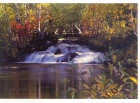
Thank you Jussi from Finland for this pretty card.

Wednesday, June 13, 2012

Lake Tahoe


Lake Tahoe is a large freshwater lake in the Sierra Nevada of the United States. At a surface elevation of 6,225 ft (1,897 m), it is located along the border between California and Nevada, west of Carson City. Lake Tahoe is the largest alpine lake in North America. Its depth is 1,645 ft (501 m), making it the USA's second-deepest (the deepest is Crater Lake in Oregon, being 300 ft (91 m) deeper, at 1,945 ft (593 m)). Additionally, Lake Tahoe is listed as the 26th largest lake by volume in the world at 122,160,280 acre·ft (150.68249 km3).
The lake was formed about 2 million years ago and is a part of the Lake Tahoe Basin with the modern lake being shaped during the ice ages. It is known for the clarity of its water and the panorama of surrounding mountains on all sides. The area surrounding the lake is also referred to as Lake Tahoe, or simply Tahoe.
Lake Tahoe is a major tourist attraction in both Nevada and California. It is home to a number of ski resorts, summer outdoor recreation, and tourist attractions. Snow and skiing are a significant part of the area's economy and reputation. Mountain and lake scenery are attractions throughout the year. The Nevada side also includes large casinos. Highways provide year-round access from Reno, Carson City, and Sacramento. Marlene from Sacramento sent me this nice card.

Thursday, June 07, 2012

Kungur Ice Cave


Despite its ancient and "exotic" story, the city Kungur is unique now because of the legendary Ice Cave in the Ice Mountain. It has got no less mysteries and secrets than Stonehenge and Egyptian sphinxes have got. Kungur Ice Mountain and Ice Cave are situated in the south-east of Perm Krai, 90 km. from the city of Perm. The area of the reservation is 106 ha, min altitude (the Baltic Sea) is 116 m, max altitude is 198 m. Kungur Ice Cave is known since time immemorial. In 1703 Peter the Great issued the decree sending a well-known geographer S.U. Remezov from Tobolsk in Kungur. He worked out the Uyezd plan and the first sketch of the Cave. The cartographers of the XVIII century made a copy of the sketch, multiplied them and they were included in the scientific encyclopaedias of the European Universities.

The Cave as an excursion site is used since 1914 and equipped with with 2 tour routes with total length of 2 km. The examination of a large excursion ring (classic route) continues 1h. 20 min. During this time the tourists travel under the ground 1300 m. Some hundred thousand people come to have a look at this unique creation of nature every year. The total number of tourists has already exceeded 5 million.

In 1733 Professor I.G. Gmelin first in the world kept the ground microclimate under observation. The constant monitoring regime in the cave is carried out over 60 years. This is the only underground laboratory in Russia with long-standing and diverse observations of karstic processes. The standard for monitoring observations in the cave is a protected part, which remains in the primordial form. Ice Mountain is of great interest in archaeological terms. There are two sites of ancient settlement of VII-IX centuries, relating to Lomovatov culture. Yermakov's site of ancient settlement known since the XIX century is located in the eastern part of The Mountain, just above Kungur Ice Cave. Kungur's site of ancient settlement , smaller in area, is situated in 0,5 km to the west of it. Both have well-preserved castle defenses - barrages and moats. This wonderful card was sent to me by Maria who lives in Perm.


Wednesday, June 06, 2012

Forests of Roztocze and woodland-tundra.


Lubelskie is located in one of the most green and ecologic clean regions of Europe. Here is located the largest in country group of Forests Janowskie and Solska Forest. Also here are stretch from Kraśnik to Hrebenne (and further to Lvov) picturesque areas of afforested hills of Roztocze. Forest land, with deep valley, numerous springs and small waterfalls on rocky terrains creates superb conditions for foot and bicycle wander. Apart from peculiarities of the nature, you will find here old country huts, antique small churches, Orthodox churches, cemeteries, and also on borderland in forests concrete bunkers from so-called Mołotow line, built hurriedly by Red Army in years 1940-41.
Roztoczański National Park protects the valuable forests of Central Roztocze, with fir-beeches forests - typical for Carpathians. Town of Zwierzyniec was formerly hunting terrain of Zamoyski family. Now it is farming of Polish pony, coming from extinct specie of forest horse - tarpan. Magda sent me this card.

Tuesday, June 05, 2012

Vyacheslav Nikolaevich Zabelin


This lovely painting was made by Vyacheslav Nikolaevich Zabelin who was born in 1935 in Khamovniki, an old region of Moscow. Zabelin recounts his childhood as having “passed by during the years when my country was engaged in a heroic war against fascist Germany”. After the war, in the late 1940’s, he had the opportunity to work in the studio of M.A. Slanov. One day as he was working in the studio, the famous artist Konstantin Yuon (student of Valentin Serov and K. Korovin) came to visit. Yuon took notice of Zabelin’s work which resulted in Zabelin’s acceptance to the “1905” Moscow Art School in 1956. His studies here continued until 1961 when he enrolled in the Surikov Institute. Zabelin spent the next six years at the Surikov, obtaining his diploma and continuing on to get his post-graduate degree. Yuon would continue to help direct Zabelin along his educational path as well as inspire his work. Mari sent me this card from Belarus. The card depicts the artist’s impression of the “morning glory over the Rostov Palace”.

Sunday, June 03, 2012

Lviv Market Square


The Rynok Square in Lviv   is a central square of the city of Lviv, Ukraine. It was planned in the second half of the 14th century, following granting city rights by Polish king Casimir III, who annexed Red Ruthenia. The king ordered Lviv to be moved more to the south, where a new city was built to the plan of a traditional European settlement: a central square surrounded by living quarters and fortifications. Old, Ruthenian Lviv had become a suburb of the new city. The square is rectangular in shape, with measurements of 142 meters by 129 meters and with two streets radiating out of every corner. In the middle there was a row of houses, with its southern wall made by the Town Hall. However, when in 1825 the tower of the Town Hall burned, all adjacent houses were demolished and a new hall, with a 65-meter tower, was built in 1835 by architects J. Markl and F. Trescher.
Around the square, there are 44 tenement houses, which represent several architectural styles, from Renaissance to Modernism. In the four corners, there are fountains—wells from 1793, probably designed by Hartman Witwer. The sculptures represent four Greek mythological figures: Neptune, Diana, Amphitrite and Adonis. In front of the Town Hall, there was a pillory. In 1998 the Market Place, together with the historic city center of Lviv, was recognized as a UNESCO world heritage site.
Julia sent me this nice card, which shows the North side of Market Square.

Saturday, June 02, 2012

Dresden - Frauenkirche


Further to my previous post (dated 01.6.2012) on the very same subject, namely the Frauenkirche in Dresden. I was fortunate to get another card depicting this famous church from Heike in Germany. So take another look.

Friday, June 01, 2012

Dresden Frauenkirche


The Dresden Frauenkirche (Church of Our Lady) is a Lutheran church in Dresden Germany. Built in the 18th century, the church was destroyed in the firebombing of Dresden during World War II. It was reconstructed as a landmark symbol of reconciliation between former warring enemies. The reconstruction of its exterior was completed in 2004, its interior in 2005 and, after 13 years of rebuilding, the church was reconsecrated on 30 October 2005 with festive services lasting through the Protestant observance of Reformation Day on 31 October. Once a month, an Anglican Evensong in English is held in the Church of Our Lady, with clergy sent from St. George's Anglican Chaplaincy in Berlin.
The conviction that the Frauenkirche that had been totally destroyed simply had to be rebuilt was shared by many people within Dresden and elsewhere too. But it took 45 years for the realisation of this dream to become a feasible possibility. And, in total, 60 years went by before the Frauenkirche in all its baroque beauty could reopen its doors to the world. Initial endeavours to start rebuilding were already undertaken in the last months of the Second World War. As the reconstruction of a church was not, however, a priority issue in the GDR (former East Germany), conditions favourable to this didn't exist until after the political changes that led to the reunification of Germany. Thanks to the impressive efforts made by the citizen's action group, the reconstruction concept was spread throughout the entire world. Over a period of 11 years and more, the church was rebuilt piece by piece - in keeping with the design specifications set out by George Bähr for the old church and using original materials to the largest extent possible. On October 30th 2005, the celebratory consecration took place to mark the conclusion of the church's reconstruction. My good friend Christina sent me this lovely card.